


Land Development Concepts in Allston
September 23, 2014
The reconstruction of the Allston Interchange of the Massachusetts Turnpike extension is not only the largest transportation construction project on the horizon in Boston, but it is also the largest opportunity for land development over the next several years. The Allston Interchange Task Force has been meeting since the spring of this year; convened by MassDOT and bringing together representatives of the residential and business community, nearby institutions, advocacy organizations, and the City of Boston, which has taken the lead in proposing development guidelines for the land, now owned by Harvard University.
At a meeting of the Task Force on August 13, Kairos Shen, Director of Planning at the Boston Redevelopment Authority, presented an analysis of the interchange area in the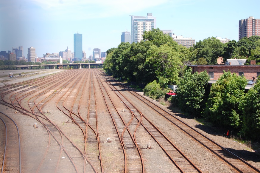 context of planning for the neighborhood and described the direction the City of Boston is heading. Mr. Shen reviewed the results of the Institutional Master Plans for Harvard and Boston University, and work in the Holton Street Planning Area and the Guest Street Planning Area. He emphasized the need to establish strong connections between the vacant freight yard and interchange, which will be reduced in size with the introduction of all electronic tolling on the Turnpike. He also showed how a traditional street grid and revitalization of Cambridge Street can set up a pattern to support development for the area.
The diagrammatic street grid and block layout suggested by the City includes potential relocation of Soldiers Field Road to create more open space along the Charles River and a street grid along the river to support development that can take the form of the Harvard residential houses located upriver. Moving west to the middle of the site, the City suggests a grid that can support institutional uses to extend adjacent planning areas. Also in this portion of the site, multi-modal connections to the proposed West Station will enhance commuter rail accessibility for the surrounding neighborhood. In the western triangle of the site, the City suggests an extension of the street grid and residential development pattern that would connect the site to the adjacent neighborhood. The City’s ideas were well received by Task Force members and will serve as the basis for discussion with MassDOT as the transportation components of the Interchange redesign are further developed.
context of planning for the neighborhood and described the direction the City of Boston is heading. Mr. Shen reviewed the results of the Institutional Master Plans for Harvard and Boston University, and work in the Holton Street Planning Area and the Guest Street Planning Area. He emphasized the need to establish strong connections between the vacant freight yard and interchange, which will be reduced in size with the introduction of all electronic tolling on the Turnpike. He also showed how a traditional street grid and revitalization of Cambridge Street can set up a pattern to support development for the area.
The diagrammatic street grid and block layout suggested by the City includes potential relocation of Soldiers Field Road to create more open space along the Charles River and a street grid along the river to support development that can take the form of the Harvard residential houses located upriver. Moving west to the middle of the site, the City suggests a grid that can support institutional uses to extend adjacent planning areas. Also in this portion of the site, multi-modal connections to the proposed West Station will enhance commuter rail accessibility for the surrounding neighborhood. In the western triangle of the site, the City suggests an extension of the street grid and residential development pattern that would connect the site to the adjacent neighborhood. The City’s ideas were well received by Task Force members and will serve as the basis for discussion with MassDOT as the transportation components of the Interchange redesign are further developed.
Comments (2)
Page:
- 1
Fran Amacher:
Sep 25, 2014 at 03:22 PM
These are great plans. I have lived in the neighborhood as a student and found the disconnection to Brookline very problematic. A connection to existing commercial centers should be emphasized with new commercial uses with public plazas along the way. Car free pathways should be along these connections. There should be a sequence of pedestrian spaces connecting this area to the river. A topography that elevates the further away you are from the river would make the space more interesting and provide long views towards the river. The elevated plane could harbor storage and car parking under it and also provide storm water storage in a catastrophic event. There is a large insufficiency for storm water storage.
Whitney Beals:
Sep 25, 2014 at 02:27 PM
The Allston rail-yard site has acres of asphalt and tracks that are not in use, soaking up heat and warming the area. Why not require the owner of this (or of any substantial site above some low threshold, say 2 acres) to plant trees (suggestion: fast-growing poplar hybrids) if it's likely that the site will be "abandoned" for more than 2 years? The trees would cool the site and produce oxygen during the growing season and, when the site is poised for redevelopment, could produce chips for biomass electric energy plants, smaller-scale CHP installations, or pellets for even smaller-scale use.